
You’ve probably landed here as a result of getting horribly lost on a WHAM Ride-out…. We have a saying in WHAM, when you dutifully download the routes and follow your satnav religiously but still end up in a one way street miles from civilisation and way off route, you’ve been ‘Garmined’.
Fear not, this page should help you iron out the problems.
History..
Your Webmaster / Routemaster has a Garmin Satnav and, selfishly, creates all of the routes using a piece of software created by Garmin called Basecamp. This is no accident, in the good old days when satnavs were rare and map users were common, the only way to plot an interesting route that used the good roads instead of the fast ones was by using software provided by Garmin and a Garmin Satnav. It was also the only way to share those routes amongst a group so that they could all ride the same roads, meet up in roughly the same place without forming a convoy of 50 bikes clogging up the best roads and travelling at the speed of the slowest rider in the group.
We used to chuck these route onto an SD card and share it around the group before setting off. These days we have this website which makes the business of sharing the routes out a lot easier.
Garmin have recently released a new generation of Sat Navs (Zumo 390LM, 590LM and the hideously expensive BMW Navigator 5) on us unsuspecting motorcyclists that seem to be resulting in WHAM Members finding new and exiting roads on their way to our breakfast meets. Nice for the adventurous but not good for the ride.
Not satisfied with releasing a load of new devices, Garmin also insist that we use a wonderfully complicated bit of software called Basecamp to design and transfer our carefully crafted routes. Basecamp gives us a host of new features that help us to get lost on Sunday Mornings.
However, all is not lost, if you read through the following explanations things should start to become clearer. Feedback, good or bad, to me please!
Waypoint.
Doesn’t refer to a point on a route specifically. A waypoint is a point that exists in the map database – either because it was there originally, or because you have added a new point to the database. You can include waypoints in a route, but a point in a route is not necessarily a waypoint.
Via Point.
Is used by the new generation devices to indicate a point on the route which it will insist that you visit. Unlike the old devices, if you missed a point on the route (maybe positioned incorrectly up a side road), but continued towards the purple highlighted route, the old device would continue navigating once you had reached the purple line. The new gen devices don’t. They nag you until you have been there.
Via points will show up in the data display eg as in ‘Time to Via’, ‘Distance to Via’.
The GPS will announce – visually and audibly – your approach to and your arrival at a Via Point.
The new generation devices give a list of all of the Via points on your route when you select a route to follow. But they show ONLY the Via points. It doesn’t show any other points.
Shaping Points
On the new generation devices, Shaping points appear as dots (small filled circles), on the route lists and on the map.
Shaping points are silent. They do not alert on arrival either visually or audibly.
Shaping points do not appear in the list of points presented by the new generation devices as ‘Select Next Destination’ options when the route is first loaded.
Shaping points will be ignored if they are slightly inaccurately placed but you remain on the purple route. (eg a point placed just up a side road). If recalculation is turned off, and (say) a new bypass has been built, then recalculation will continue correctly as soon as you join the purple route again. Even if the bypass missed out visiting the shaping point.
Recalculation
Will take place if you have the option turned on. Recalculation always results in the original route from planned in Basecamp being over-ruled and a new route is plotted using the routing preferences that are set in the GPS. But it will always calculate a route to the next Via Point or Shaping point.
The notion that you must have the routing preferences set to be the same as was set in Basecamp is a false one. Basecamp has many more preferences. the new generation devices have 3 – faster, shortest, curvy. (Plus the avoidances of course). You can use the setting to approximate to what you had in Basecamp, but they are only ever used if the GPS performs a recalculation. Not otherwise.
The GPS knows what was plotted in Basecamp by virtue of the fact that when the route is transmitted, it transmits the start, end, via and shaping points that have been plotted, but it also transmits hundreds of invisible intermediate points as GPX extensions. I call them ‘Ghost Points’ and they force the GPS to take you along precisely the same roads that were in the route in Basecamp. When the GPS is forced to recalculate, (different maps, going off route), the first thing that gets lost is these extra points in the current section. The Via points and shaping points remain, but the GPS has to calculate its own route in between the last and the present points. It also explains why circular routes go horribly wrong if a recalculation takes place at any point along the route.
The moral of the story for those creating their own routes is to include lots of shaping points.
The routes you find on the website have had all of the via points and waypoints converted to shaping points except for the start and end points. You should check this is the case before you send any route (including WHAM routes created by me) to your device. To do this, double click on the route in Basecamp and make sure all the points on the route are greyed out and say ‘Don’t alert on arrival’ except for the start and finish points.
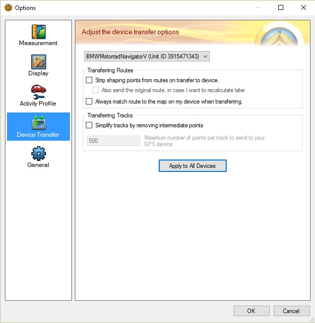
Device Transfer Preferences.
- It is critical that you set this up correctly.
- Launch Basecamp..
- Click on Edit..
- Select ‘Options’..
- Select Device Transfer
- Make sure your Device is selected in the Drop down box..
- Un-check all check boxes in this dialogue so that it looks as follows:
If you are new to Basecamp or just want to get to know the programme better I suggest you follow this link.
The document was created by a Guy called Ed Conde, from New England Riders in the States, its a great resource.
UPDATE – SEPTEMBER 2022.
OK – So, you’ve all read the article on the website that explains the difference between shaping points and via points,
Your GPS will always insist that you visit a via point (“Alert on arrival in Basecamp”). If you miss a via point it will try to turn you around to go back and visit it unless you hit the ‘skip’ button on the GPS screen. If you miss a shaping point (“Don’t alert on arrival” in Basecamp)the GPS will not care and should carry on routing you to the next shaping point or via point. All nice and logical….. Until you start the route……
When you start the route you will be presented with a ‘Select Next Destination’ option. These destinations are always via points (‘Alert on Arrival’ in Basecamp). Lets say the first destination is McDonald’s Malvern and you select that one then the GPS will expect you to visit McDonlald’s Malvern. That’s fine if you are at the actual waypoint, but if you are parked a few yards away and don’t actually pass through the actual waypoint then the GPS will keep trying to send you back there until you press the skip button…… This is a common issue.
Second scenario is that when presented with the ‘Select Next Destination’ options you don’t select the correct one. The destination you select here will be used by the GPS as the next destination and will skip any previous destinations (including the shaping points) and take you straight to the one you selected using your default routing options. So, it follows that if you select the final destination and are not at the actual location of the first destination then your GPS will send you straight to the final destination and ignore any intermediate shaping or via points.
The way around all of the above issues is to ALWAYS SELECT THE SECOND DESTINATION in the ‘Select Next Destination’ box.
Activity Profiles
Personally, I create all my routes using the ‘Driving’ profile in Basecamp and have my GPS set to ‘Driving’. Regardless of which profile you use, the GPS will still try to send you to the next shaping point, if you have a different activity profile to me then your GPS may send you on a different route between them.